
The National Weather Service reports that widespread rain was falling over the Bay Area for the morning commute. Moderate to heavy rain and thunderstorms were expected later Wednesday with winds between 35-55 mph.
The weather service has warned most of the Bay Area is under flood watch as residents are to prepare for flooding, downed trees, power outages and closed roadways.
Many cities have issued notices to residents regarding sandbags, downed trees and how to report flooding.
Per National Weather Service (4:46 am on 1/4/23)
A potent atmospheric river will begin to impact the region today and continue into Thursday. This will bring substantial rainfall to the San Francisco Bay Area and Central Coast on top of already saturated soils. As a result look for rapid rises in area creeks, streams, and rivers. Bankfull exceedance is possible. In addition strong gusty winds will bring branches and trees down, which may cause localized damming of water ways.
San Francisco-Marin Coastal Range-Sonoma Coastal Range-North Bay Interior Mountains-Coastal North Bay Including Point Reyes National Seashore-North Bay Interior Valleys-San Francisco Bay Shoreline-San Francisco Peninsula Coast-East Bay Interior Valleys-Santa Cruz Mountains-Santa Clara Valley Including San Jose-Eastern Santa Clara Hills-East Bay Hills-Southern Salinas Valley/Arroyo Seco and Lake San Antonio-Santa Lucia Mountains and Los Padres National Forest-Mountains of San Benito County And Interior Monterey County including Pinnacles National Park-Northern Salinas Valley/Hollister Valley and Carmel Valley-Northern Monterey Bay-Southern Monterey Bay and Big Sur Coast-Including the cities of Livermore, Pleasanton, Angwin, San Francisco, Hayward, Oakland, Lagunitas-Forest Knolls, Boulder Creek, Sausalito, Santa Rosa, Berkeley, South Santa Rosa, Antioch, San Ramon, Santa Cruz, Fremont, San Jose, Tamalpais-Homestead, Rohnert Park, San Rafael, Watsonville, Day Valley, Seaside, Walnut Creek, Petaluma, Live Oak, Blackhawk, King City, Concord, Napa, Pittsburg, Salinas, Scotts Valley, Monterey, Pacifica, Marina, Greenfield, Daly City, Woodacre, and Novato
…FLOOD WATCH REMAINS IN EFFECT THROUGH THURSDAY AFTERNOON…
* WHAT…Flooding caused by excessive rainfall continues to be possible.
* WHERE…Entire San Francisco Bay Area and Central Coast including: Sonoma, Napa, Marin, Contra Costa, Alameda, San Francisco, San Mateo, Santa Clara, Santa Cruz, San Benito, and Monterey counties.
* WHEN…Through Thursday afternoon.
* IMPACTS…Excessive runoff may result in flooding of rivers, creeks, streams, and other low-lying and flood-prone locations. Creeks and streams may rise out of their banks. Flooding may occur in poor drainage and urban areas. Low-water crossings may be flooded. Storm drains and ditches may become clogged with debris. Extensive street flooding and flooding of creeks and rivers are possible.
* ADDITIONAL DETAILS… – http://www.weather.gov/safety/flood
PRECAUTIONARY/PREPAREDNESS ACTIONS…
You should monitor later forecasts and be alert for possible Flood Warnings. Those living in areas prone to flooding should be prepared to take action should flooding develop.
Current Road Closures in Unincorporated Contra Costa County
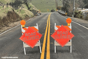 Contra Costa County, CA – Due to flooding, mudslides, and other issues caused by the recent storms, Contra Costa County Public Works has closed the following roads until further notice:
- Marsh Creek Road is closed between Deer Valley Road & Morgan Territory Road due to continued rock and mudslides. Only residents are allowed in the area. Please take alternate routes to avoid this area.
- Morgan Territory Road is closed between 5477 Morgan Territory Road-5649 Morgan Territory Road due to mudslides. Only residents are allowed in the area.
- Deer Valley Road is closed to all traffic in both directions between Briones Valley Road and Marsh Creek Road due to a sinkhole. Please take alternate routes to avoid this area.
- Highland Road is closed between Collier Canyon Road and Camino Tassajara due to rock/mudslides. Only local traffic is allowed through the area as crews work to clear the road.
Danville Declares Local Emergency Due to Storms and Flooding
The Town of Danville has proclaimed a local emergency due to severe storms expected this week, following flooding and mudslides after the December 31 storm. Acting in the capacity of Director of Emergency Services, Town Manager Joe Calabrigo signed the proclamation just before noon, and it will expire at noon on January 10. The local emergency proclamation allows the town greater flexibility to contract for and procure supplies for more expedient disaster response.
The Town has deployed all available maintenance staff and contractors for clean-up ahead of a second atmospheric river storm expected January 4. — Full Story
Regional Parks Closed Through Thursday Due to Upcoming Atmospheric River Storm System
Due to expected storm conditions and high winds, all East Bay Regional Parks are closed Wednesday, January 4, 2023, through Thursday, January 5, 2023. The National Weather Service has issued a flood watch and high wind warning for the San Francisco Bay Area with flooding, landslides, and rapidly rising rivers and creeks possible.
Public safety is the Park District’s top priority. Residents should not enter closed parks. Public safety personnel may not be able to respond to emergencies due to road and trail conditions. Anyone entering Regional Parks when closed is subject to citation or arrest for violation of the Park District’s Ordinance 38. — Full Story
Sandbag Locations Throughout Contra Costa County
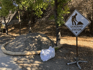 With rain expected, Contra Costa County and local cities are offering sandbags to residents and many cannot keep them full–for example, the Town of Danville reported that more than 5,000 sandbags have been provided to residents. Many cities are also checking ID to residents who show up to fill bags.
Here is a list of locations and options and remember be sure to check up to date info with which location — full story
Storm Preparedness and Safety Tips from PG&E
- PG&E encourages customers to have a plan, prepare for power outages, and above all else, stay safe.
- Customers can get updates on outages in their neighborhood through a variety of channels.
- Contact our outage information line at 1-800-743-5002
- Access our Electric Outage Map online at com
- Customers can also log in to their account through com and sign up to receive proactive outage alerts through email, text, or phone.
- Never touch downed wires: If you see a downed power line, assume it is energized and extremely dangerous. Do not touch or try to move it—and keep children and animals away. Report downed power lines immediately by calling 911 and by calling PG&E at 1-800-743-5002.
- Use flashlights, not candles: During a power outage, use battery-operated flashlights, and not candles, due to the risk of fire. If you must use candles, please keep them away from drapes, lampshades, animals, and small children. Do not leave candles unattended.
- Have a backup phone: If you have a telephone system that requires electricity to work, such as a cordless phone or answering machine, plan to have a standard telephone or cellular phone ready as a backup.
- Have fresh drinking water, and ice: Freeze plastic containers filled with water to make blocks of ice that can be placed in your refrigerator/freezer during an outage to prevent foods from spoiling. Blue Ice from your picnic cooler also works well in the freezer.
- Secure outdoor furniture: Deck furniture, lightweight yard structures, and decorative lawn items should be secured as they can be blown by high winds and damage overhead power lines and property.
- Use generators safely: Customers with standby electric generators should make sure they are properly installed by a licensed electrician in a well-ventilated area. Improperly installed generators pose a significant danger to customers, as well as crews working on power lines. If using portable generators, be sure they are in a well-ventilated area.
- Turn off appliances: If you experience an outage, unplug or turn off all electrical appliances to avoid overloading circuits and to prevent fire hazards when power is restored. Simply leave a single lamp on to alert you when power returns. Turn your appliances back on one at a time when conditions return to normal.
- Safely clean up: After the storm has passed, be sure to safely clean up. Never touch downed wires and always call 8-1-1 or visit com at least two full business days before digging to have all underground utilities safely marked.
Winter Driving
- Streetlights: At night, the streets will be much darker than usual and will look different. Follow all posted speed limits – or drive a bit slower. Use turn signals when changing lanes and especially at corners with crosswalks.
- Traffic Signals: If traffic signals are out or flashing red, come to a full stop at every intersection, and proceed as you would at a four-way stop.
- Keep emergency gear in your car when you’re traveling in areas with snow and ice, including Cell phone, Flashlights, Jumper cables, Sand or kitty litter (for traction), Ice scraper or snow brush, Blankets, Warning devices (such as flares or reflectors)
If your vehicle comes in contact with a downed power line:
Stay inside! The safest place is in your car. The ground around your car may be energized. Honk the horn, roll down your window and yell for help. Warn others to stay away. Anyone who touches the equipment or ground around the vehicle may be injured. Use your mobile phone to call 911. The fire department, police, and PG&E workers will tell you when it is safe to get out of the vehicle.
If there is a fire and you must exit a vehicle that has come in contact with downed power lines:
Remove loose items of clothing. Keep your hands at your sides and jump clear of the vehicle, so you are not touching the car when your feet hit the ground. Keep both feet close together and shuffle away from the vehicle without picking up your feet.