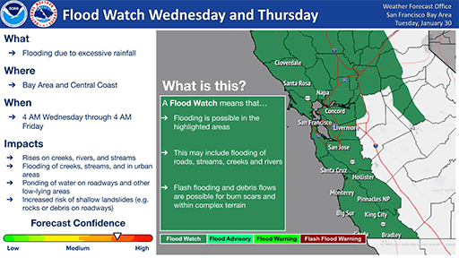
The National Weather Service has issued a flood watch for the San Francisco Bay Area, including Contra Costa County. Flood watch remains in effect until Thursday night. California will be impacted by two significant atmospheric rivers over the next 7-10 days,
Rain and wind is expected early Wednesday morning to early Thursday morning with high confidence in 4-6 inches total for the coast, with 3-4 inches in the North Bay and 2-3 inches elsewhere in the Bay Area/Central Coast
- Rain Reaches North Bay Tuesday evening
- Greatest impacts expected Wednesday
- Greatest Rain totals in the North Bay and Coastal Ranches
- Highest wind gusts for the mountains and coast, specifically the Santa Cruz mountains and Santa Lucia Mountains.
A high wind warning is in effect for Wednesday with strong southerly winds with gusts of 45-mph or greater in the Bay Area and Central Coast. This warning is in effect from 4:00 am Wednesday to 4:00 am Thursday.
Contra Costa County Sandbag Locations: Click Here
Official Notice:
.Model guidance continues to suggests greatest accumulation of precipitation will be observed across the North Bay and along the coastal ranges. Rainfall totals remain consistent with 1.5 to 3 inches expected across most areas with 3-5 inches expected over the North Bay. Locally up to 6 to 8 inches over favored peaks and higher terrain of the the North Bay and up to 4 to 6 inches in the Santa Cruz and Santa Lucia Mountains.
San Francisco-Marin Coastal Range-Sonoma Coastal Range-North Bay Interior Mountains-Coastal North Bay Including Point Reyes National Seashore-North Bay Interior Valleys-San Francisco Bay Shoreline-San Francisco Peninsula Coast-East Bay Interior Valleys- Santa Cruz Mountains-Santa Clara Valley Including San Jose- Eastern Santa Clara Hills-East Bay Hills-Southern Salinas Valley/Arroyo Seco and Lake San Antonio-Santa Lucia Mountains and Los Padres National Forest-Mountains of San Benito County And Interior Monterey County including Pinnacles National Park-Northern Salinas Valley/Hollister Valley and Carmel Valley-Northern Monterey Bay-Southern Monterey Bay and Big Sur Coast-
Including the cities of South Santa Rosa, Scotts Valley, Woodacre, Novato, Boulder Creek, Antioch, Petaluma, King City, Sausalito, Tamalpais-Homestead, Seaside, Daly City, Napa, San Francisco, Pleasanton, Cordoza Ridge, Blackhawk, Live Oak, Fremont, Pittsburg, Marina, Lagunitas-Forest Knolls, Pacifica, San Ramon, San Jose, Angwin, Livermore, Hayward, Santa Cruz, Walnut Creek, Salinas, San Rafael, Berkeley, Monterey, Watsonville, Rohnert Park, Concord, Day Valley, Oakland, Santa Rosa, and Greenfield
1156 PM PST Mon Jan 29 2024
FLOOD WATCH REMAINS IN EFFECT FROM LATE TUESDAY NIGHT THROUGH LATE THURSDAY NIGHT
- WHAT…Flooding caused by excessive rainfall continues to be possible.
- WHERE…Portions of central and northern California, including the following areas, in central California, Mountains of San Benito County And Interior Monterey County including Pinnacles National Park, Northern Salinas Valley/Hollister Valley and Carmel Valley, Santa Lucia Mountains and Los Padres National Forest, Southern Monterey Bay and Big Sur Coast and Southern Salinas Valley/Arroy Seco and Lake San Antonio. In northern California, Coastal North Bay Including Point Reyes National Seashore, East Bay Hills, East Bay Interior Valleys, Eastern Santa Clara Hills, Marin Coastal Range, North Bay Interior Mountains, North Bay Interior Valleys, Northern Monterey Bay, San Francisco, San Francisco Bay Shoreline, San Francisco Peninsula Coast, Santa Clara Valley Including San Jose, Santa Cruz Mountains and Sonoma Coastal Range.
- WHEN...From late Tuesday night through late Thursday night.
- IMPACTS…Excessive runoff may result in flooding of rivers, creeks, streams, and other low-lying and flood-prone locations. Flooding may occur in poor drainage and urban areas. Low-water crossings may be flooded. Storm drains and ditches may become clogged with debris.
ADDITIONAL DETAILS…
– Periods of moderate to heavy rainfall will bring the potential for moderate to rapid rises along area rivers, streams, and creeks across the region. This could result in nuisance as well as minor flooding. Although many sites are forecast to remain below flood stage, several locations may reach and exceed flood stage across the region.
Ensemble guidance shows a greater than 50 percent chance of reaching flood stage on numerous rivers and creeks across the North Bay and monitor stage on the San Lorenzo River at Big Trees and numerous other locations across the San Francisco and Monterey Bay Area by Thursday.
– http://www.weather.gov/safety/flood
PRECAUTIONARY/PREPAREDNESS ACTIONS…
You should monitor later forecasts and be alert for possible Flood Warnings. Those living in areas prone to flooding should be prepared to take action should flooding develop.


